Tours and Activities:
Surrounding the General Carrera
Mónica Pons Jorge GonzálezEach river population, no matter how small it is, has its own main feature. And altogether, many of them make up a circuit of excellent proposals amidst a natural environment.

Leaving Chile Chico towards the west is an invitation to border Lake General Carrera along a mountain road that covers each geographical feature and always displays the water body. Thus, Puerto Ingeniero Ibañez is reached. In the last few years, this district has increased its tourist activities as a result of the rich natural reserves lying in the surrounding area.
We started driving at Chile Chico and came across several small very picturesque towns on the way, as well as lodges and inns where fishing outings and hiking tours were offered. We continued up to Puerto Guadal, a small settlement with a delightful sandy beach and warm waters that turn it into a highly coveted destination during the summer.

A little farther ahead, Puerto Bertrand tempts everyone to stay for a rest and try fly-fishing at the lake bearing the same name and up to the start of the Baker River. At the point where Lakes Carrera and Bertrand connect, a viewpoint left us speechless. We caught a glimpse of both lakes and the landscape in silence and continued along a gorge that got us deep into a forest of native species, including coihues, lengas and ñires. Another viewpoint located on Contreras Mountain Range was as imposing.
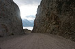
We drove on along a gravel road which looked as if it was made of compressed salt. It was always narrow, with cornices and typical mountain features.

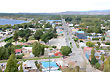
Once on the Southern Road, which would lead us to Puerto Murta, we let ourselves be carried away by the wild geography of this area in Chilean Patagonia. As we got to Puerto Río Tranquilo, we were curious about the motorboat excursions to the so-called Capillas de Mármol. At the same time, we visited this small hamlet with few denizens but with a charming kind of simplicity.
We continued driving towards Puerto Murta always escorted by the General Carrera to our right. We covered its bay, the valley and its mountains and realized that its nautical activities lure a great deal of tourists.
At this point, the Southern Road deviates from the coast to reach Puerto Ibañez. We failed to see two abandoned towns: Puerto Cristal and Puerto Venado, which used to boast a significant active population that lived on mining in the past.

Puerto Ingeniero Ibañez welcomed us with a great affluence of visitors, as it offers various interesting outings towards the Ibañez River Falls, the Levican Peninsula and Mount Castillo with its eternal snow and vestiges of the Tehuelche culture. To complete the ride, we took the barge that crosses the lake onto Chile Chico. It follows a straight line that coincides with the international border. Both populations lie on the frontier and are connected with the Argentinian Districts of Palavicini and Los Antiguos, respectively.

Our ride around Lake General Carrera came to an end on the Chilean side. We got to see the populations lying on its shores, many of which used to be connected only by water. We still have to do the same circuit on the Argentinian side, where the lake is called Buenos Aires.
 See also:
 © 2007-2025 Total or partial reproduction forbidden. Derechos de Autor 675243 Ley 11723